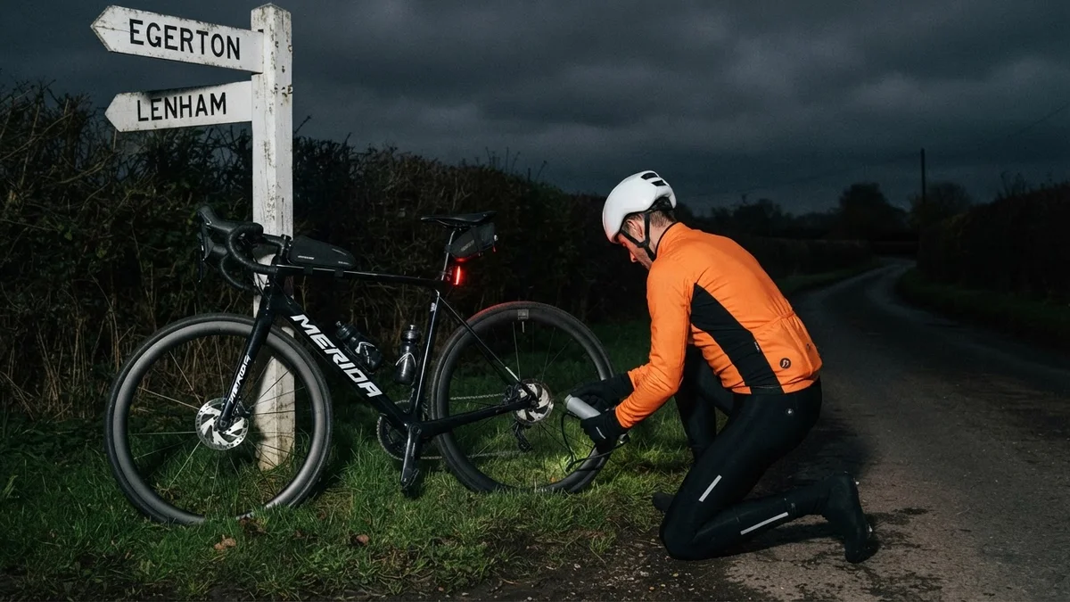
A slow puncture shaped this night ride in Kent. The first half was an ordinary run east across the Weald to Egerton; the second was ride, stop and pump, all the way home along the Greensand Ridge.
I set off into a dry, cloudy night at 8°C with only the faintest northerly, dropped down Hunton Hill and rolled south through Chainhurst to Marden. From there the flat roads ran on through Staplehurst to Headcorn, and the lanes were close to empty: just 20 vehicles passed me all night.
Beyond Headcorn I took Smarden Road and Bedlam Lane east, then turned north for Egerton and the only real climbing of the ride. Rock Hill Road gains 82 m in just over a kilometre, and Coach Road comes soon after, climbing on from Stonebridge Green towards the top of the ridge.
Somewhere on those climbs the back tyre began to soften. A slow puncture is more nuisance than drama: no tube change by the roadside in the dark, just top it up and keep going while it holds. Once the climbing was done I pulled onto the verge, leaned the bike against a fingerpost and let my little Cycplus AS2 Pro electric pump do the work. It weighs 120 g, shows the pressure as it goes and stops by itself when it gets there, which is exactly what you want at the side of a dark lane.
That set the pattern for the way home. Lenham Road took me west under the ridge to Ulcombe, the next top-up came on Chartway Street below Sutton Valence, and there was one more near Boughton Monchelsea before the last few kilometres through Linton. The stops added up to about a quarter of an hour, and Garmin’s segment from Ulcombe to Sutton Valence shows it, at more than double my best time. Each top-up lasted just long enough to reach the next, and the proper fix can wait for daylight.
The numbers
- Ride: #1144 on Strava, ride 273 of 2026, day 153 of the streak
- Distance: 49.6 km
- Moving time: 2:13:49 (2:27:56 elapsed)
- Elevation: 360 m
- Average power: 118 W
- Heart rate: 120 bpm average, 155 max
- Cadence: 91 rpm average
- Calories: 1,132 kcal
- Highlight (Strava segment): Rock Hill Road, Egerton – 1.06 km, 82 m, 4:48 at 204 W
- Conditions: dark and cloudy, 8°C, 90% humidity, the faintest northerly
- Kit: Cycplus AS2 Pro electric pump, three top-ups of the back tyre
- Year to date: Distance 21,881 km, Elevation Gain 222,357 m
The route
● Favourite Garmin segment ● Shorter segment inside a longer one The numbers match the Segments table below. Hover over a segment for its time and rank; click or tap for a link to it on Garmin Connect.
Download the GPX (start and finish trimmed for privacy)
13 favourite Garmin segments. Best placed: Chainhurst Hill, 0.51 km at 1.6%, 26th of my 44 goes (from km 4). Time and power are from this ride; My rank places this ride among all my own goes at that segment. The numbers match the map, and each segment name links to Garmin Connect, where you can save it (you’ll need a Garmin account).
Segments table
| # | Segment | Starts at km | Length | Ascent | Avg grade | Time | Avg speed | Avg power | My rank | My best |
|---|---|---|---|---|---|---|---|---|---|---|
| 1 | Hunton Hill Down | 0.8 | 0.79 km | 0 m | -8.0% | 1:12 | 39.5 km/h | – | 38 of 42 | 0:47 |
| 2 | Chainhurst Hill | 3.8 | 0.51 km | 9 m | 1.6% | 1:24 | 22.0 km/h | 174 W | 26 of 44 | 0:52 |
| 3 | Pattenden Lane Sprint | 7.3 | 0.50 km | 0 m | 0.4% | 1:13 | 24.5 km/h | 180 W | 132 of 142 | 0:39 |
| 4 | Marden to Staplehurst | 10.4 | 2.15 km | 12 m | 0.1% | 5:34 | 23.2 km/h | 187 W | 13 of 14 | 3:40 |
| 5 | Staplehurst to Headcorn | 13.2 | 6.28 km | 33 m | -0.1% | 15:55 | 23.7 km/h | 191 W | 16 of 17 | 11:30 |
| 6 | Smarden Rd to Bedlam Ln | 20.8 | 1.98 km | 9 m | 0.1% | 5:08 | 23.1 km/h | 210 W | 22 of 27 | 3:13 |
| 7 | Rock Hill | 28.3 | 0.70 km | 43 m | 6.0% | 3:24 | 12.4 km/h | 243 W | 111 of 127 | 2:19 |
| 8 | Stonebridge Green Coach Rd | 29.9 | 2.19 km | 45 m | 1.1% | 7:23 | 17.8 km/h | 223 W | 12 of 14 | 4:45 |
| 9 | Park Rd | 33.5 | 1.06 km | 12 m | 0.4% | 3:11 | 19.9 km/h | 252 W | 9 of 12 | 2:03 |
| 10 | Lenham Rd | 35.0 | 3.25 km | 32 m | 0.2% | 8:46 | 22.2 km/h | 209 W | 11 of 14 | 6:21 |
| 11 | Ulcombe to Sutton Valence | 37.5 | 4.06 km | 9 m | -0.5% | 15:06 | 16.2 km/h | 189 W | 132 of 135 | 6:57 |
| 12 | Sutton Valence to Boughton Monchelsea | 41.5 | 3.85 km | 5 m | -0.5% | 9:32 | 24.2 km/h | 235 W | 150 of 175 | 6:45 |
| 13 | Cock to lights | 45.4 | 1.86 km | 10 m | 0.6% | 7:49 | 14.3 km/h | 182 W | 215 of 218 | 3:06 |
The profile and climbs
3 climbs, all uncategorised. Biggest: 0.9 km at 5.9%, 52 m of climbing (from km 28). Together the climbs account for 112 m of the ride’s ascent. Garmin and Strava measure climbs and segments over their own start and finish points, so the figures here can differ from the Highlight above and from each other.
● Uncategorised Pins mark where each Garmin ClimbPro climb starts. Hover or tap a pin for details.
Climbs table
| # | Climb | Category | Starts at km | Length | Ascent | Avg grade | Time | Avg speed | Avg power | My rank | My best |
|---|---|---|---|---|---|---|---|---|---|---|---|
| 1 | Rock Hill Road | Uncategorised | 28.2 | 0.89 km | 52 m | 5.9% | 4:09 | 12.8 km/h | 220 W | 114 of 127 | 2:42 |
| 2 | Coach Road | Uncategorised | 29.9 | 0.84 km | 37 m | 4.4% | 3:23 | 14.9 km/h | 201 W | 133 of 153 | 2:19 |
| 3 | near Boughton Malherbe | Uncategorised | 31.9 | 0.78 km | 23 m | 2.9% | 2:44 | 17.1 km/h | 194 W | 141 of 153 | 1:43 |
My rank places this ride among my outdoor rides over the same climb on Garmin up to that day, matched by GPS, and My best is the fastest of them at the time. Time and speed include any stop on the climb.
Related
Related rides
- Egerton by Headlight: the same climbs out of Egerton, with nothing to stop for on the way home
- Sun, Fog and a Flat: the last puncture, at the top of Hollingbourne Hill in thick fog
Kit on this ride
- Cycplus AS2 Pro: the electric pump that kept the slow puncture going all the way home
Every town, café, beach and landmark from my rides is collected on the Links page.